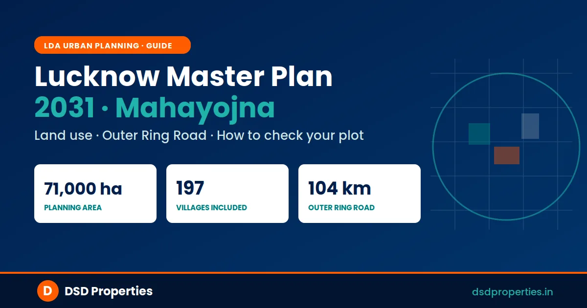
Lucknow Master Plan 2031 (Mahayojna 2031) — 71,000 Hectares, 197 Villages, Outer Ring Road: The Complete Guide
Sources: Lucknow Development Authority (ldalucknow.in master plan map & ldaonline.co.in master plan document), LDA TOD & State Capital Region pages, UP Town & Country Planning Department, Lucknow district portal (lucknow.nic.in) tehsil/village directory, and published reports (ETV Bharat, Amar Ujala, Amrit Vichar, 2015–2026). Figures are indicative of the plan as published; always confirm current land use directly with LDA before any property decision.
The Lucknow Master Plan 2031 — Mahayojna 2031 — is the single most important document deciding how Lucknow grows: where you can build, what each plot is meant for, and which land is off-limits. Prepared by the Lucknow Development Authority (LDA) with the Town & Country Planning Department, it is the city's statutory land-use blueprint up to the year 2031.
For anyone buying a plot or flat in Lucknow, this is not academic. The master plan is exactly what separates a safe, sanctioned investment from an illegal colony that can be demolished. This guide breaks the plan down in plain language — its area and scope, a map of the region, the 197 villages tehsil-by-tehsil, the 104 km Outer Ring Road, how to check whether your own plot is included, and how it differs from the separately approved "Master Plan 2041" that confuses many buyers.
⚠️ The Master Plan in 60 Seconds
- What it is: LDA's statutory land-use plan (Mahayojna 2031) guiding planned development of the Lucknow Development Area to 2031
- How big: about 71,000 hectares, bringing in roughly 197 villages from 5 tehsils, pushing the urbanised share from ~40% to ~70%
- GIS-based: land use, plot details and illegal-plotting information are being made available online — a tool to verify plots and curb land mafias
- Backbone: a 104 km Outer Ring Road with a "new Lucknow" of residential and commercial hubs planned along it
- Not the same as "2041": the approved Master Plan 2041 is a separate UPSIDA industrial corridor plan, not the LDA city plan
The Area at a Glance — Map
The master plan covers Lucknow city and a wide ring of surrounding land brought into the Lucknow Development Area. The map below shows that region — the city core along the Gomti, and the peripheral belts (along Sultanpur Road, Kanpur Road, Faizabad Road, Sitapur Road, Hardoi Road and Raebareli Road) where most of the 197 added villages and the new Outer Ring Road development sit.
Indicative map of the Lucknow region covered by the plan. The exact statutory boundary and plot-level land use are defined in the official LDA master plan; use the LDA map portal for precise zoning.
What is the Lucknow Master Plan 2031 (Mahayojna 2031)?
A master plan, or mahayojna, is a long-term statutory document that divides a city's planning area into zones — residential, commercial, industrial, green/recreational, public and semi-public, transport, and so on — and fixes how much of each land use is allowed and where. The Lucknow Master Plan 2031 is that document for the Lucknow Development Area, prepared by LDA together with the state's Town & Country Planning Department. Every legal layout, building approval and land-use decision in the city is supposed to conform to it.
Geographically, Lucknow sits between roughly 26°30′ and 27°10′ north latitude and 80°30′ and 81°13′ east longitude, and has grown outward in all directions along the Gomti River. Mahayojna 2031 succeeds the earlier revised plans (the 2021-era plan, which itself built on the 2001 revision) and is designed to manage the next wave of growth in a planned way rather than letting development sprawl haphazardly.
The plan went through the standard statutory process — a draft, a public-objection stage (LDA invited suggestions and objections up to 14 October 2022), and a government committee review in 2023 that asked for certain revisions, which were addressed. LDA has also been carrying out the GIS survey work needed to map land use down to the plot level, including across the newly added villages.
Area & Scope: How Big Is the Plan?
Scale of Mahayojna 2031
- Total planning area: approximately 71,000 hectares
- Villages brought in: around 197, integrated into the urban planning area
- Tehsils covered: drawn from Lucknow's five tehsils — Lucknow (Sadar), Sarojini Nagar, Bakshi Ka Talab, Mohanlalganj and Malihabad
- Urbanised share: rising from roughly 40% today to about 70%
- Residential zone: the largest land use, expanding substantially — reported to grow to about 30,750 hectares (close to 48% of the planned area)
In simple terms, large stretches of what were villages and farmland on Lucknow's edges are being formally folded into the city's planned area, with land uses fixed for each. That is why so many "new Lucknow" schemes — from Gomti Nagar Extension to the newer townships along Sultanpur Road and Kisan Path — sit on land that the master plan re-designated for urban development.
The 197 Villages — Where They Are (Tehsil-Wise)
One of the most common questions is "is my village in the master plan?" The roughly 197 villages folded into the Lucknow Development Area are drawn from the district's five tehsils. The exact, complete list of all 197 villages is part of the official LDA master plan notification schedule — it is not something to take from an unofficial blog, because a wrong list can mislead a buyer about whether a specific village is included. Below is where the additions are concentrated, tehsil by tehsil, followed by how to confirm a specific village.
The central city and eastern growth belt — Gomti Nagar, Gomti Nagar Extension and Chinhat side — where much of the planned residential and commercial development is concentrated.
The fast-growing belt along Sultanpur Road, Kisan Path and Kanpur Road — home to many newer townships, group-housing schemes and the airport side of the city.
The northern belt along Sitapur Road and Kursi Road, an expanding direction for residential and institutional growth on the city's edge.
The southern belt towards Raebareli Road — a large rural-urban fringe being progressively brought into planned development.
The Hardoi Road and Kakori–Malihabad side — known for its mango belt, with parts entering the planning area along the western corridors.
If you want the precise village schedule, the authoritative places are the LDA master plan notification and the tehsil-wise village directory on the Lucknow district portal (lucknow.nic.in). Treat any "full list" you find on a property website with caution unless it matches the official notification.
How to Check if Your Village or Plot Is Included
Rather than rely on a list, the reliable way is to check the official records for your specific plot. Here is the step-by-step:
Identify your tehsil and village
Know the exact revenue village name and tehsil (Sadar, Sarojini Nagar, BKT, Mohanlalganj or Malihabad) and, ideally, your khasra/khata number.
📍 lucknow.nic.in → tehsil/village directoryOpen the LDA master plan map / GIS portal
Locate your village/area on the official LDA master plan map and see whether it falls within the development area, and what land-use zone it is shown in.
📍 ldalucknow.in → Master Plan MapRead the land-use zone
Identify the zone for the precise plot — residential, commercial, industrial, green/recreational, transport or agricultural — from the plan's colour coding.
📍 Match the plot to its zone colourCross-check the revenue records
Verify the same plot by khasra number on UP Bhulekh / Bhu-Naksha — confirming ownership and land classification (agricultural vs non-agricultural).
📍 upbhulekh.gov.in & upbhunaksha.gov.inConfirm the layout is approved
Check the plot is not in an unauthorised/illegal colony and the layout is LDA-approved. When in doubt, confirm with LDA or get an independent verification before paying.
📍 LDA approved-layout / illegal-colony listKey Objectives of the Plan
What the plan is trying to achieve
- Planned urban growth — regulating land use so the city expands in an orderly way instead of through unauthorised colonies
- Modern infrastructure — stronger roads, footpaths, drainage, sewerage, water supply and solid-waste management
- Economic & industrial growth — space for IT hubs, trade centres and new business districts
- Environmental conservation — green zones, eco-sensitive areas and protection of water bodies
- Heritage & tourism — preserving Lucknow's historic precincts and cultural landmarks
Land-Use Zones & Key Provisions
The plan divides the area into land-use zones. These are the main categories you will see on the master plan map:
Residential expansion. Residential is the dominant land use, expanding well beyond the earlier plan to accommodate growth — which is what unlocks new sectors and group-housing schemes on the periphery.
Apartments on smaller plots. As reported in the plan provisions, apartment construction may be permitted on plots as small as 200 square metres, provided the abutting road is at least 9 metres wide. Because building bye-laws are updated periodically, confirm the current rule with LDA before planning any construction.
Commercial, industrial & green zones. The plan earmarks land for commercial and trade centres, industrial and IT activity, recreational/green spaces, and public uses such as schools and hospitals — the everyday infrastructure a growing city needs.
The 104 km Outer Ring Road & "New Lucknow"
If the plan has one physical centrepiece, it is the 104 km Outer Ring Road (ORR). LDA's vision is to develop a "new Lucknow" along the ORR, building residential and commercial hubs on both sides of the corridor. Several practical shifts are tied to it:
What the Outer Ring Road plan involves
- Residential and commercial hubs developed along both sides of the 104 km corridor
- Many of the city's wholesale markets relocated to the ORR periphery to decongest the core
- New bus stations and improved inter-city connectivity
- A proposed new airport referenced in the planning vision
- Special emphasis on links to Kanpur Road, Faizabad/Barabanki Road, Hardoi/Kakori Road and Sultanpur Road
For investors, the ORR matters because corridors like this tend to anchor the next decade of value growth — but only where development is sanctioned. Land along an expressway is not automatically residential; its land use is still governed by the master plan, so the verification discipline above applies just as strongly here.
TOD Zones and the State Capital Region
Two further layers sit alongside the core plan. First, LDA is implementing Transit Oriented Development (TOD) along the Lucknow Metro corridor, in line with the national TOD policy and the UP TOD Policy 2022. Within the master plan framework, a TOD zone has been delineated along the Metro, with a Metro Influence Zone of 500 metres on either side of the alignment — areas where denser, mixed-use, transit-friendly development is encouraged.
Second, LDA has delineated a wider State Capital Region (SCR) around Lucknow, comprising six districts — Lucknow, Unnao, Rae Bareli, Barabanki, Sitapur and Hardoi. The SCR is a regional planning idea, similar in spirit to the NCR around Delhi, aimed at coordinating growth across the capital's wider catchment rather than just the city core.
Master Plan 2031 vs the "Master Plan 2041" — Don't Confuse Them
This trips up a lot of buyers, so it is worth being precise. The LDA city land-use plan is Mahayojna 2031. The separately approved Master Plan 2041 is a different document altogether:
The two plans, side by side
- Lucknow Master Plan 2031 (LDA): the city's statutory land-use plan for the Lucknow Development Area — residential, commercial, civic and green zoning
- Master Plan 2041 (UPSIDA, erstwhile LIDA): an industrial corridor plan along NH-27 in Lucknow and Unnao — reported at 75,000+ acres, with roughly 10,000 acres for industry and the rest for residential, commercial, green belt, transport and logistics
- Different authorities, different purpose: 2031 is LDA's city plan; 2041 is UPSIDA's industrial-region plan tied to the State Capital Region and UP's industrial push
So if you see "Lucknow Master Plan 2041" headlines, they almost always refer to the UPSIDA industrial plan. For checking whether a residential plot inside the city is legal and correctly zoned, the document that governs you is the LDA Mahayojna 2031.
Why the Master Plan Matters When You Buy
It is easy to treat the master plan as something only town planners care about. In reality, it is the most important due-diligence check a Lucknow buyer can make. A plot's market price means nothing if the land use does not permit what you intend to do with it.
Buying inside the sanctioned land use protects you on every front: bank home loans are sanctioned more readily on approved-layout property; the unit can be registered and mutated cleanly; and you are far less exposed to LDA enforcement, sealing or demolition that hits unauthorised colonies. Conversely, a "cheap" plot in an unapproved layout or on agricultural land sold as residential can become impossible to finance, register or resell — and in the worst case, a target for demolition.
Common Mistakes to Avoid
🚨 Assuming "near the highway" means residential
Proximity to the Outer Ring Road or an expressway does not change a plot's land use. Agricultural or transport-zoned land stays that way until formally converted. Always read the actual zone on the master plan.
🚨 Buying in an unapproved or illegal colony
Layouts that do not conform to the master plan and lack LDA approval are vulnerable to enforcement. Check the plot against the approved-layout and illegal-colony information before paying anything.
🚨 Skipping the agricultural-land check
Agricultural (Krishi) land cannot be used for housing without proper conversion. Confirm the land classification in the Bhulekh records, not just the seller's word.
🚨 Trusting a brochure over the official plan
Glossy project brochures are marketing, not zoning. The binding reference is the LDA master plan and revenue records — verify there, independently.
How DSD Properties Helps
Reading a master plan map and matching it to revenue records is exactly the kind of check most buyers skip — and exactly where DSD Properties adds value. Our property verification service turns the master plan from a confusing map into a clear yes/no on whether your plot is safe:
What our verification covers
- Land-use zoning check — confirming the plot's zone under Mahayojna 2031
- Village inclusion check — whether the village falls within the LDA development area
- Revenue-record cross-check — Khatauni and land classification on UP Bhulekh
- Approved-layout & illegal-colony screening against LDA records
- A documented PDF report within 48 hours so you can buy with confidence
The Bottom Line
The Lucknow Master Plan 2031 (Mahayojna 2031) is the rulebook for how the city grows — about 71,000 hectares, 197 villages across five tehsils, a jump in the urbanised share from roughly 40% to 70%, a GIS-based system you can check online, and a 104 km Outer Ring Road that will shape the next "new Lucknow." Layered on top are Metro TOD zones and the six-district State Capital Region, while the separately approved UPSIDA Master Plan 2041 handles the industrial corridor.
For a buyer, the single most valuable habit is simple: before you pay for any plot or flat, check it against the master plan and the revenue records. Do that — yourself or through an independent verification — and you sidestep the biggest, most expensive mistakes in Lucknow real estate.

Leave a Comment